

What to Know
- Remnant moisture from Tropical Storm Mario will move through Southern California on Thursday.
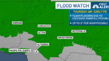
- A flood watch is in effect for burn scar areas in Altadena and the Pacific Palisades
- Some locations will get little to no rain, while others could get up to at least half an inch of rain.
Showers and thunderstorms are expected to hit Southern California Thursday morning, bringing the chance of flash flooding across Los Angeles County.
“It will be warm and muggy through Friday as remnants of tropical storm Mario move into the area. Temperatures will cool through the period but humidities will be much higher than normal,” the National Weather Service said Tuesday night.
Rain and thunderstorms begin overnight and continue all day Thursday. While storms can pop up just about anywhere in SoCal, the bulk of the moisture sticks inland and over the mountains and deserts through the afternoon and evening on Thursday, according to NBCLA Meteorologist Shanna Mendiola.
A flood watch is in effect for most of the mountains from San Luis Obispo to Los Angeles County beginning Thursday morning, according to the NWS. Burn scar areas in Altadena and Pacific Palisades are also on flood watch.
“Rain and thunderstorm chances will begin Wednesday night and continue into at least early Friday. Over the weekend into early next week there is (a) slight chance of showers as additional moisture from the south arrives. The muggy weather will continue into early next week.”
Forecasters said confidence is growing that most areas across Southern California will get at least some rain between Wednesday afternoon and Thursday. Amounts are expected to be highly variable, with some areas possibly just getting around a tenth of an inch, and other areas as much as 1-2 inches.
Heads Up: A flood watch is in effect for most of the mountains from San Luis Obispo to LA Co from early Thur morning – Thur night. This corresponds with a broad swath of rain expected to arrive during the overnight hours. Stay tuned for updates. #socal #cawx #CArain pic.twitter.com/P8MU0wevtV
— NWS Los Angeles (@NWSLosAngeles) September 17, 2025
The best chance for any lightning would likely be as the moisture is just arriving Wednesday night into early Thursday, after which the environment may be too moist with too much cloud cover to support thunder development.
“With the upcoming shower/thunderstorm chances, the most hazardous impacts Wed into early Thur will be dry lightning & localized strong winds,” according to the NWS’ Los Angeles office. “As more moisture arrives Thur, the threat shifts to flooding & potential for debris flows in and around recent burn scars.”
Daytime temperatures are expected to drop about 5 degrees from Tuesday’s scorcher, which saw highs in the mid-to-upper 90s in the valleys. Overnight lows will be much warmer than normal as well into early next week as the moisture aloft will trap a lot of the heat from the daytime. Overnight lows in the upper 60s and low 70s are expected to be the norm in the inland areas.