

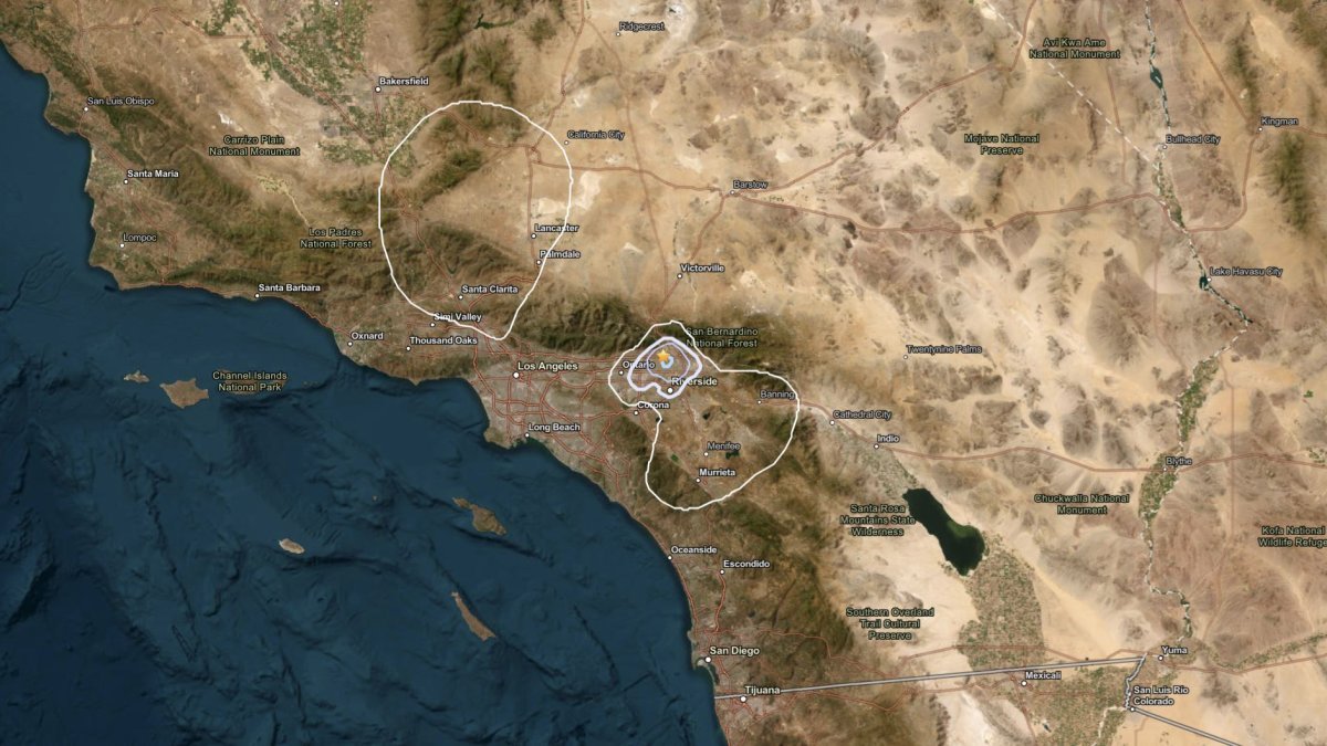

A preliminary magnitude-4.3 earthquake and smaller quakes in the San Bernardino area produced shaking Thursday morning that was felt over widespread parts of Southern California.
The quake, reported at about 9:30 a.m., was one of four of magnitude-2.5 or greater just west of San Bernardino, a region that includes the communities of Fontana, Muscoy and Rialto.
A magnitude-3.0 quake was reported at 8:34 a.m. in the San Bernardino County community about 50 miles east of Los Angeles. Shaking was reported in Riverside, San Bernardino and other inland areas.
The second stronger quake was reported at about 9:30 a.m. Shaking was reported in Los Angeles, Santa Monica, Torrance, Long Beach, Pasadena and other areas.
The initial magnitude changed several times as more data became available.
A magnitude-3.1 aftershock was reported about four minutes later.
Can we really predict earthquakes? Two top seismologists explain why it’s so hard and what we can actually do to stay prepared.
Several smaller earthquakes have been reported Thursday morning before and after the largest shock. Aftershocks, the sequence of quakes after a larger mainshock, become less frequeNt over time, but can continue for days, weeks, months and even years after a powerful mainshock.
The area has seen about 130 quakes of magnitude 3.0 and greater since 1990, many coming in clusters. There have been eight quakes of magnitude-4.0 since that time.
“This is a very active region,” said seismologist Dr. Lucy Jones, adding that Thursday’s activity was standard fare for Southern California and its vast network of earthquake faults.
There were no reports of significant damage.
Did you feel it?
Whether you feel shaking from an earthquake largely depends on three major factors — magnitude, distance and local soil conditions.
Magnitude refers to the strength of the quake. The closer your location to the epicenter, the more likely you’ll feel the effects of seismic waves that become less intense as they move out from the fault. Generally, the looser the soil under your location, the greater the amplification.
Did you feel it? Let us know below.
| Magnitude | Date | Location | Notes |
|---|---|---|---|
| 7.9 | Jan. 9, 1857 | Fort Tejon | Two killed; 220-mile surface scar |
| 7.8 | April 18, 1906 | San Francisco | Possibly 3,000 killed; 225,000 displaced |
| 7.4 | Mar. 26, 1872 | Owens Valley | 27 killed; three aftershocks of magnitude 6 or greater |
| 7.4 | Nov. 8, 1980 | Eureka | Injured 6; $2 million in damage |
| 7.3 | July 21, 1952 | Kern County | 12 killed; three magnitude 6-pluys aftershocks in five days |
| 7.3 | June 28, 1992 | Landers | One killed; 400 injured; $9.1 million in damage |
| 7.2 | Jan. 22, 1923 | Mendocino | Homes damaged in several towns |
| 7.2 | April 25, 1992 | Cape Mendocino | 356 injuries; $48.3 million in damage |
| 7.1 | Nov. 4, 1927 | Lompoc | No major injuries; light damage in two counties |
| 7.1 | Oct. 16, 1999 | Ludlow | Minimal damage due to remote location |
| 7.1 | July 5, 2019 | Ridgecrest/Trona | Preceded by 6.4-magnitude quake; no fatalities |
| 7.0 | May 18, 1940 | El Centro | 9 killed; $6 million in damage |
| 6.9 | Oct. 17, 1989 | Bay Area | 63 killed; 3,753 hurt; up to $10 billion in damage |
| 6.7 | Jan. 17, 1994 | Northridge | 57 killed; 9,000 hurt, up to $40 billion in damage |
| 6.6 | Feb. 9, 1971 | San Fernando | 65 killed; 2,000 injured; $505 million in damage |
| 6.4 | March 10, 1933 | Long Beach | 115 killed; led to new building codes for schools |